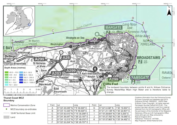
Government does a lot of stuff with maps, and if you like maps you might like to know about this clever trick for finding every single one that gets published on GOV.UK.
Start off at the Publications page, which by default shows you everything - all publications, on all topics, from every department. Look closer, though, and you'll see the filter tools on the left that allow you to drill down to the stuff that you're interested in.
For maps, then, click the "Publication type" filter and select Maps from the list. The list of tens of thousands of publications is suddenly reduced to a much more manageable few dozen.
If you're a really keen map addict (some people are), you can use the updates tools at the top of the filtered list to sign up for an email alert every time a new map is published, or grab a RSS feed (shout out to the RSS massive).
We're just using maps as an example, but there's lots more you can discover lurking behind the publication filters. Whether you want to see open public consultations on business and enterprise or independent reports published by the Department of Education or perhaps transparency data from the Treasury, it's all there.
Either way, enjoy the maps.
You may also be interested in:
A checklist for digital inclusion

3 comments
Comment by simonfj posted on
Thanks Again Giles, (you really do have the best job)
It's funny, you have pointed to two services that, to me, would seems ripe for transformation - Maps and Consultations.
Ok, so we know the old way of working with maps is to gather completed publications and then try and aggregate& filter a particular view from between them. We also know, thanks to (e.g. Google) mapping platforms that the new way is to have the one perimeter map (say of the UK) to which various digital managers can contribute their 'slice' or 'overlay'. Then researchers can just, as you've done with this list, filter the big picture, and developers can mash up new services. Every country has their priorities. https://toiletmap.gov.au/
Creating a National standard for mapmakers/data contributors is the key here.
The other service - consultations - is not quite as easy as it's so much about revealing the conversations which go on around an inquiry, and (in research) relating them to other inquiries. This new form of (online) education still battles with a citizen's natural disposition to either rant (because they've never had an outlet for their ideas or are a tenured prof) or remain silent (because they've been taught to shut up and listen; or, in the design of public digital services, "watch this space").
It's pretty obvious we are all being led here by design concepts which revolve around an LMS platform. Take you pick. http://govstore.service.gov.uk/cloudstore/search/?q=LMS Added to this - and we're having this discussion on a few LinkedIn ( Video-as-a-Service and Educause) groups at the moment - Real Time Communications needs to be added. RTC is a combination of all your ideas about presence, streaming, video conferencing, etc - and including a watching/participating audience in an inquiry. In short, an asynchronous learning environment with a RTComms hub 'embedded' in the url/domain.
The talk is about "virtual rooms" or "virtual labs". Which design approach always depends on whether the digital manager needs to just host general services (al la Google or FB), or whether their audience/co-producers need to access more secure special services. (one joke at a recent conference; the reply to which was "NO, you cannot access the hadron collider using your FB account" 🙂
Now that all the gov.uk domains have been bought together, bringing the same Local and National services together becomes much easier. FYI, This is the network manager's perspective when trying to tie services together across domains. http://www.geant.net/Network/Research-and-Education-Networks/Pages/Home.aspx (campus = department)
The key to running inclusive and ongoing consultations is addressing the new organisational norm; at least it is in the R&E space. I.e.The subdomains will be/are built for topic groups. So e.g. Mapmakers (et al) know where to go and meet, communicate with their National and Local peers and coordinate their activities. gds.groups.gov.uk ?
I notice on the drop down for the publications page there's an unused "International Locations". i.e. It can only provide a UK perspective of International issues. Might be useful to consider this as part of the OGP platform. You can imagine what the NREN guys have been attempting for the past 10 years. They just don't employ Digital Service designers, cause it's a new profession. Interesting to watch a new professional grow, eh? Upwards!
Comment by Adam Branscomb posted on
I know you meant this as an example, but (at least in the case of maps) don't you think that this kind of publication can be greatly improved upon in a digital service? Departments could be publishing interactive maps, and possibly integrating them with the map-based search on data.gov.uk. As an example, here is a far more interactive map publication from Kent County Council:
http://www.arcgis.com/apps/MapTour/index.html?appid=1ba486f80db647d3b264358702074fa5&webmap=c5b8f917dcef4486ac8b7ce10f5a0561
Comment by Peter G posted on
Totally agree.
The way maps are dealt with at the moment on GOV.UK are as static documents - a throwback to when most things existed as paper documents. We don't need to be stuck with this concept in the digital age, so much better to establish some open standards for mapping for government - and maybe develop / buy a UK gov mapping platform as a commodity plug-in component for both back office and digital services. Maybe based on Open Street Map or similar?